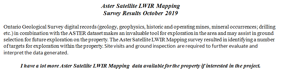


|
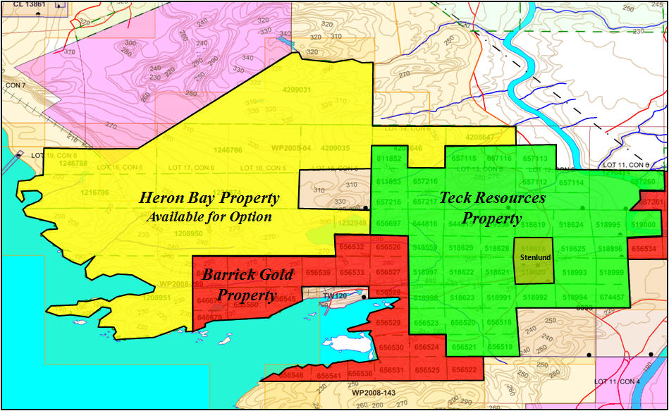
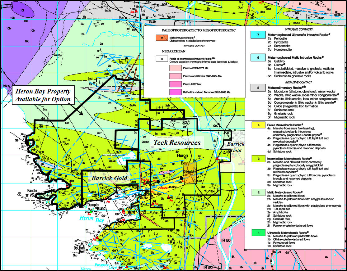
Heron Bay Gold Potential Property Heron Bay Property ties on to Teck Cominco & Barrick Gold Properties Property Description: The Heron Bay Property consist of 79 claim cell blocks of the favorable Hemlo-Heron Bay shear with Porphyry Zones on the property and a Gold occurrence of 2.25 g/t Au in intermediate to felsic pyroclastic rock. The Heron Bay property is located 27 kilometers west of the Hemlo Gold Mines, west/northwest of Metal Corp. and south of Marathon PGM Corp. The Heron Bay property ties on to Teck Cominco's property and Barrick Gold property in the PIC Twp. claim map G-0630, in the Thunder Bay Mining Division. (See claim location maps below).
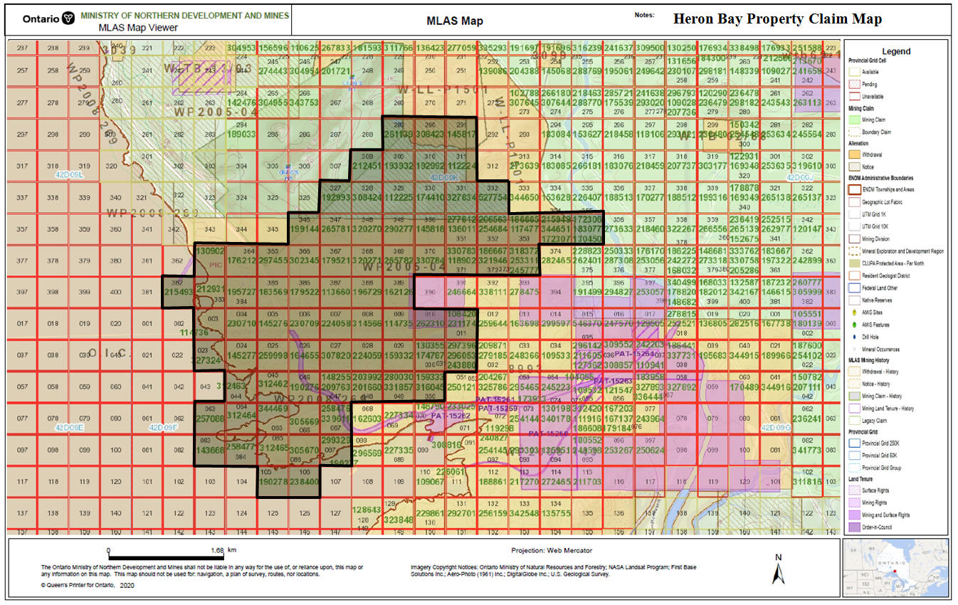
Heron Bay Property: The Heron Bay Property consists of 79 cell claim blocks unpatented contiguous mining claims ( 79 units, 1,168 hectare ) recorded in good standing in Thunder Bay Mining Division within the PIC Twp. G-0630 Claim cell blocks including boundary cell claim units: 327324, 258477, 344469, 312464, 305669, 527754, 330784, 330783, 327834, 321946, 320271, 320270, 314566, 312465, 312463, 312462, 308424, 308423, 307820, 305670, 302345, 297455, 297396, 290277, 277812, 265782, 265781, 262310, 261139, 259998, 258476, 257088, 245777, 238400, 230710, 230709, 224059, 224058, 215493, 212931, 212451, 206563, 199144, 196729, 195727, 193932, 192993, 192992, 190278, 190277, 190276, 183569, 179522, 179521, 176212, 174410, 172307, 172306, 164655, 162126, 159332, 145818, 145817, 145277, 145276, 143668, 130902, 130355, 117477, 114736, 114735, 113660, 112225, 112224, 108420, 209763, 203992, 331857, 159333
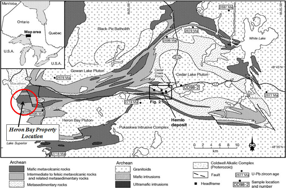
The Property lies in the gold structure of Heron Bay: The important gold zones found to date are in the Felsic volcanics near the contact with metasediments on the Teck Cominco Limited property (The Stenlund property). Highlights from previous drilling include 9.3 grams per tonne gold (g/t Au) and 184 g/t silver (Ag) over 7.3 m in ST98-11 and 12.6 g/t Au and 365 g/t Ag over 3.0 m in ST98-09. Access: The claims lie on the east shore of Lake Superior about 3 Km WNW of the settlement of Heron Bay. The C.P.R. railway crosses the centre in north-south direction and access to the claims can be made by following the tracks from the Heron Bay station some 3 Km. Alternately the west end of the group can be gained by boat from the waters of Heron Bay, a distance of some 4 Km. Regional Geology:The Hemlo gold deposit originally contained at least 80 million tonnes at an average grade of 7.7 g/t. The Williams Mine is located at the western end of the Hemlo deposit, the David Bell Mine at the eastern end and Newmont�s Golden Giant Mine in the central position.The Hemlo deposit lies on the south side of the east-west trending Hemlo-Heron Bay Greenstone Belt of Archean volcanic and metasedimentary rocks in a major ductile dextral shear zone. In the vicinity of the Williams and David Bell mines the supracrustal rocks are divided into the Playter Harbour Group (mafic volcanic rocks) and the Heron Bay Group (felsic volcanics and metasediments). The Heron Bay Group dips to the north, structurally overlies the Playter Harbour Group, and contains all the economic gold deposits found to date at Hemlo. The ore is generally associated with the Moose Lake Porphyry (MLP) and is characterized by intense silicification and the presence of gold, molybdenum, arsenic, antimony, mercury, vanadium and barite.
General Geology: The general geology of the property is located within the Schreiber-Marathon green stone belt in the Superior Province of the Canadian Shield. More specifically, the property lies within an Archean metasedimentary - metavolcanic belt trending easterly from the Heron Bay area on Lake Superior. Plutonic rocks constitute a major portion of the map area. The Hemlo gold camp is also located within a portion of the Schreiber- Marathon greenstone belt, and lies approximately 28 km to the east of the property. The general geology of the property is shown on the Heron Bay Sheet, Map 2439, which was mapped by and reported on by T.L. Muir, and associates or the Ontario Department of Mines, 1981. The oldest rocks in the area, with the exception of the pukaskwa Gneissic Complex (Bennett et al, 1969 ) are the felsic, intermaediate, and mafic volcanic rocks, two suites of volcanic rocks are present: a tholeitic suite consisting of iron-rich basalt and minor andesite, which lies in the southern part of the regional map area which is termed the Pulpwood-Playter Harbour sequence; and a calc-alkalic suite consisting of dacite to rhyolite pyroclastic breccia, lapilli tuff and crystal tuff as well as lesser andesite and basalt which lies in the northern part of the map area termed the Heron Bay Sequence. Iron formation and thin intercalated tuff and sediment units are present in the tholeiitic rocks to the south (T.L. Muir, 1982, O.G.S Report 218). Siltstone, wacke, and shale units are present within or adjacent to the intermediate to felsic puroclastic rocks of the Heron Bay sequence. Minor andesite and basalt also occurs within this sequence. The property lies within the Heron Bay Sequence. This portion of intermediate pyroclastic rocks and intercalated metasediments is sandwiched between two massive plutons. The Gowan Lake Pluton, which lies to the north, covers the northeastern corner of the property and is a porphyritic biotite-hornblende quartz monzonite. The Heron Bay Pluton, to the south, consists of a porphyritic (plagioclase) biotite-hornblende granodiorite. All of the above mentioned volcanic and sedimentary rock suites are intruded by Late Precambrian felsic dikes and sills, and all previously mentioned rocks except those of the Alkalic complex are intruded by more extensive diabase dikes. A common orientation of the diabase dikes is northerly. Property Geology: The property lies about 27 kilometers west of the Hemlo Gold Deposit in a similar series of rocks. Briefly, the Hemlo Series consists of: (1) Mafic metavolcanics, (2) Intermediate to felsic volcanics, (3) Metasediments. The volcanic succession which underlies the Heron Bay Property, forms part of the Heron Bay Sequence and is at least 2200 meters wide on the property. These rocks can be subdivided into four major sequences: a) A northern sequence of mafic, pillowed flows that is pervasively silicified and carbonatized giving outcrops a more Afelsic@ appearance. These are probably Ableached@ magnesium tholeiitic basalts. b) A central zone of 1200 meters thick consisting of a succession of interbedded finto medium-grained tuffs of intermediate composition with local interbedded volcaniclastic horizons. c) A southern sequence of finer intermediate pyroclastics with interbedded fine grained mafic flows and tuffs associated volcaniclastic metasediments. d) A southwestern sequence occurs best exposed along the lakeshore on the south-western portion of the property with interbedded felsic aphanitic light green flows and spherulitic flows.
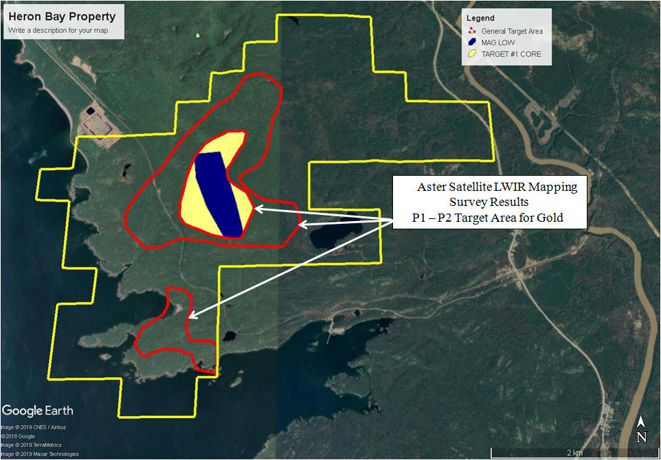
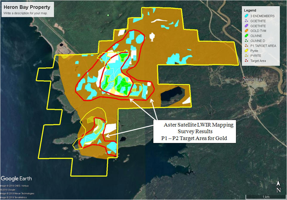
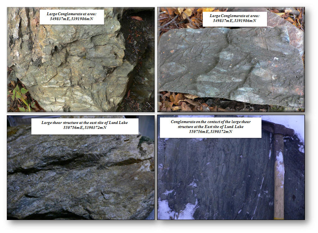
Conglomerate and shear structure on the Heron Bay property. The shear structure has anomaly Gold values.
|