


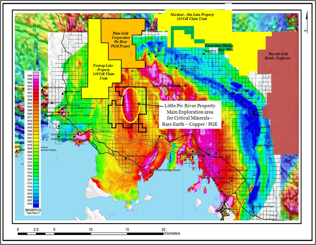
Little Pic River property Critical Minerals – Rare Earth – Copper / PGE potential
70 contiguous mining cell claim units recorded in good standing in Thunder Bay Mining Division within the Grain Twp. G-0628 .
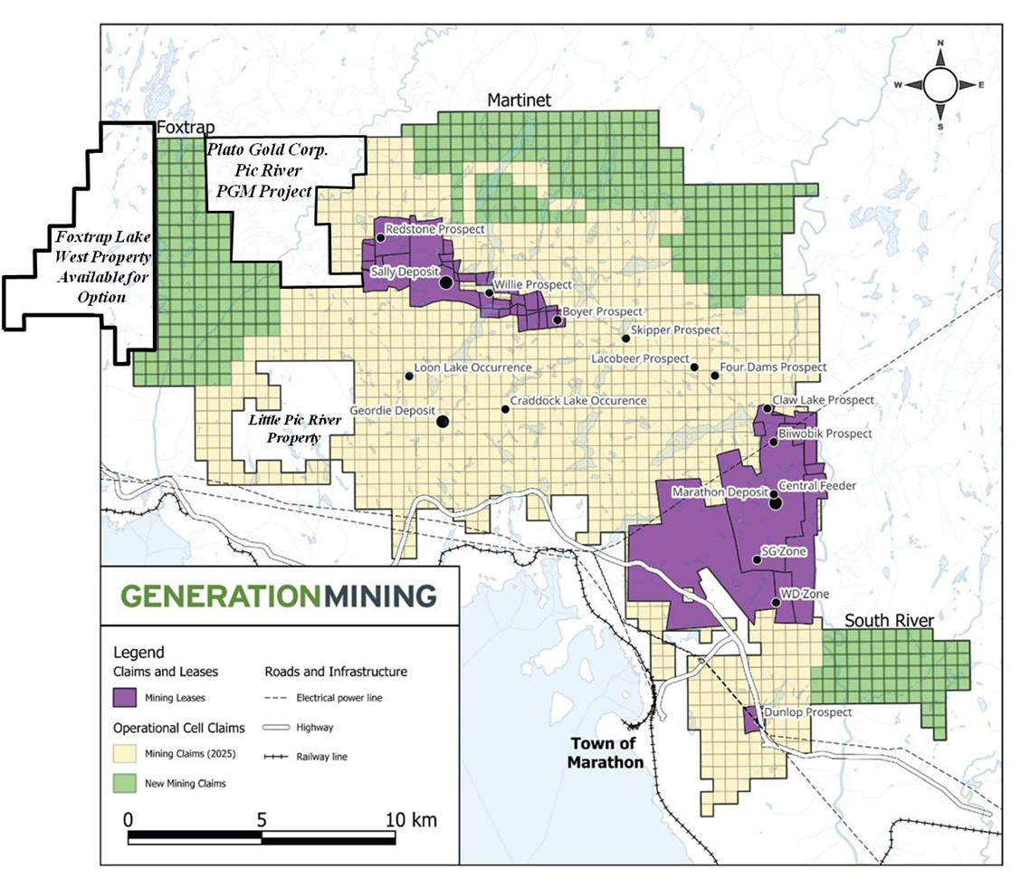
Strategic Land Expansion by Generation Mining December 2025
GENERATION MINING EXPANDS ITS LAND PACKAGE AT THE MARATHON DISTRICT
https://genmining.com/news/2025/generation-mining-expands-its-land-package-at-the-marathon-district/
Generation Mining Acquired 451 new mining claims in the Marathon District, expanding its land package by 36% to 36,398 hectares. See news release December 31, 2025
https://genmining.com/news/2025/generation-mining-yearend-2025-newsletter/
This expansion strengthens exploration potential around the Coldwell Complex, opening new targets for copper and palladium discoveries.

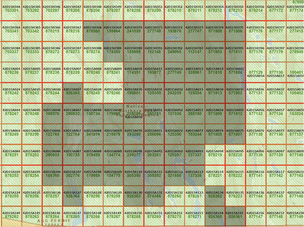
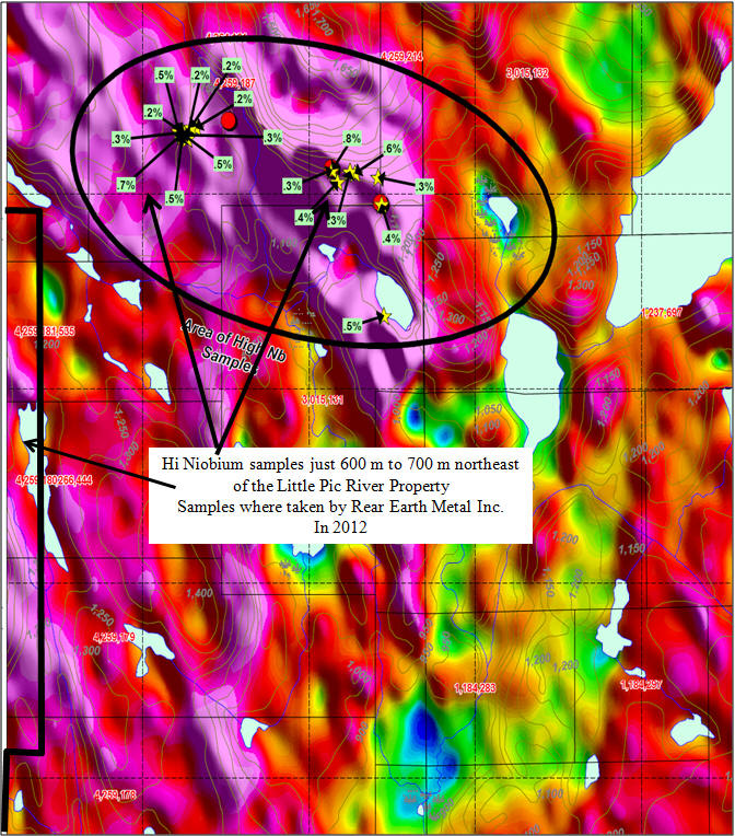
New Updated Claim Map Little Pic River Property
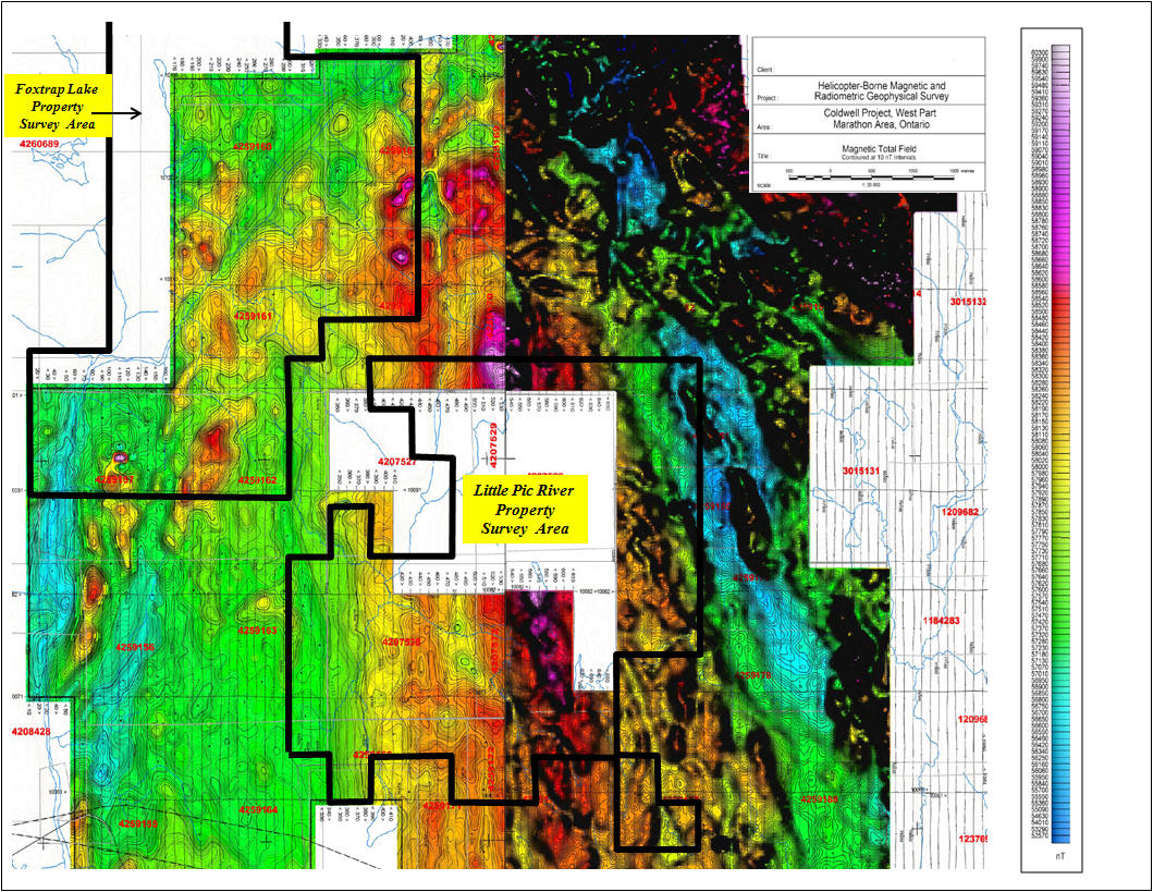
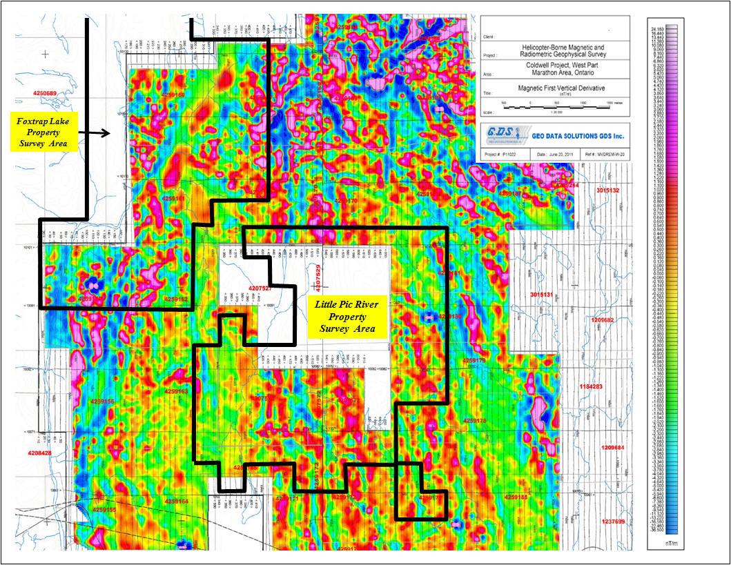
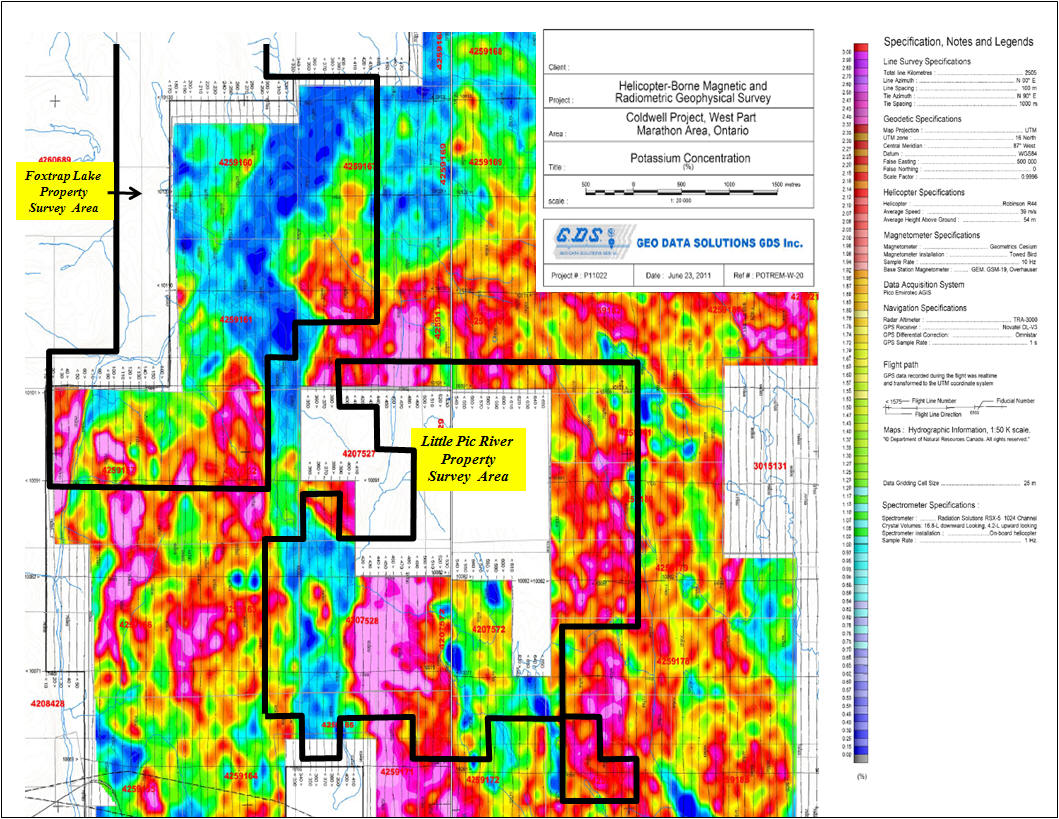
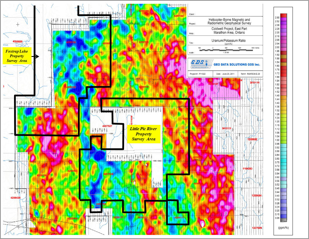
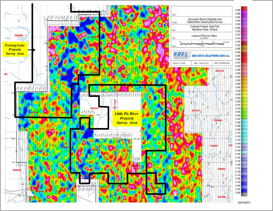
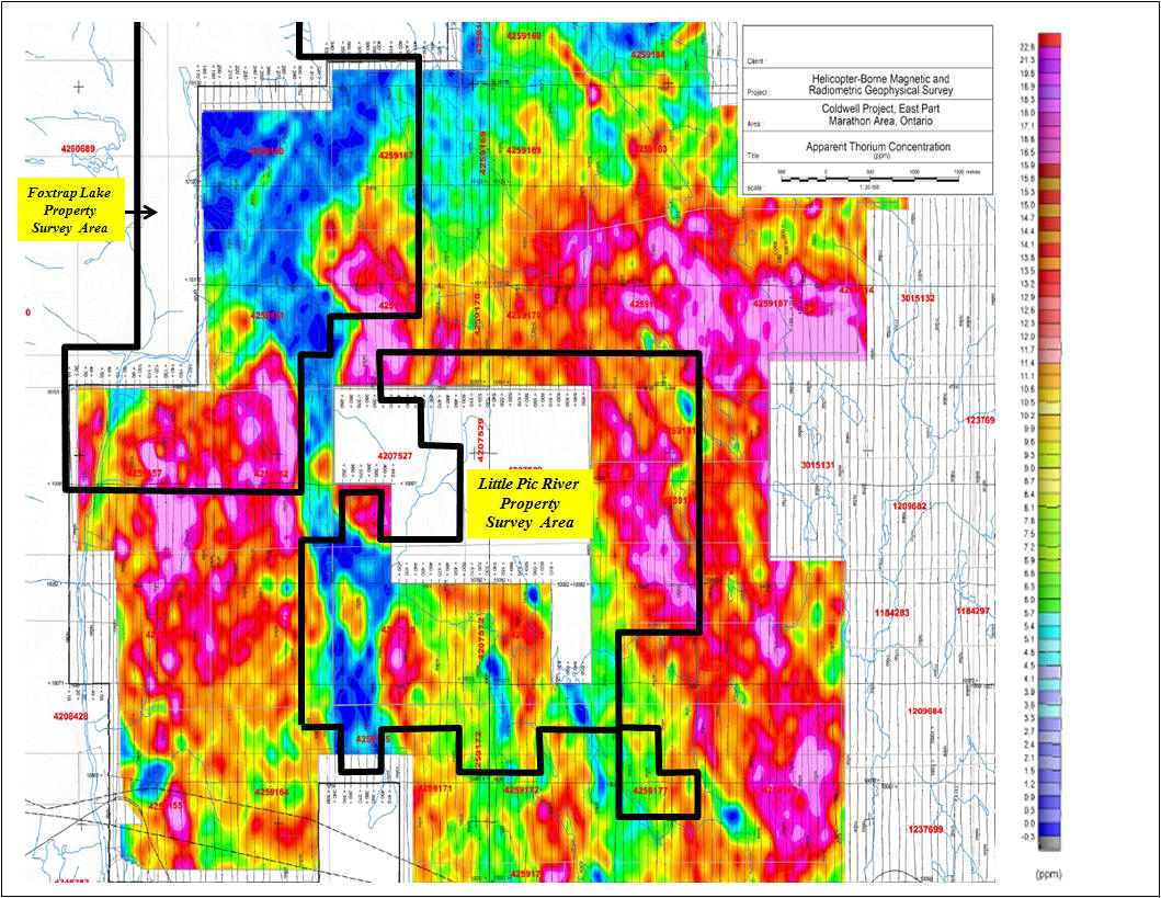
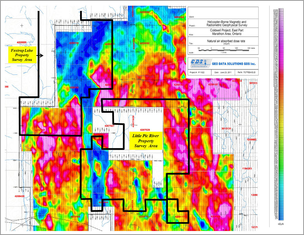
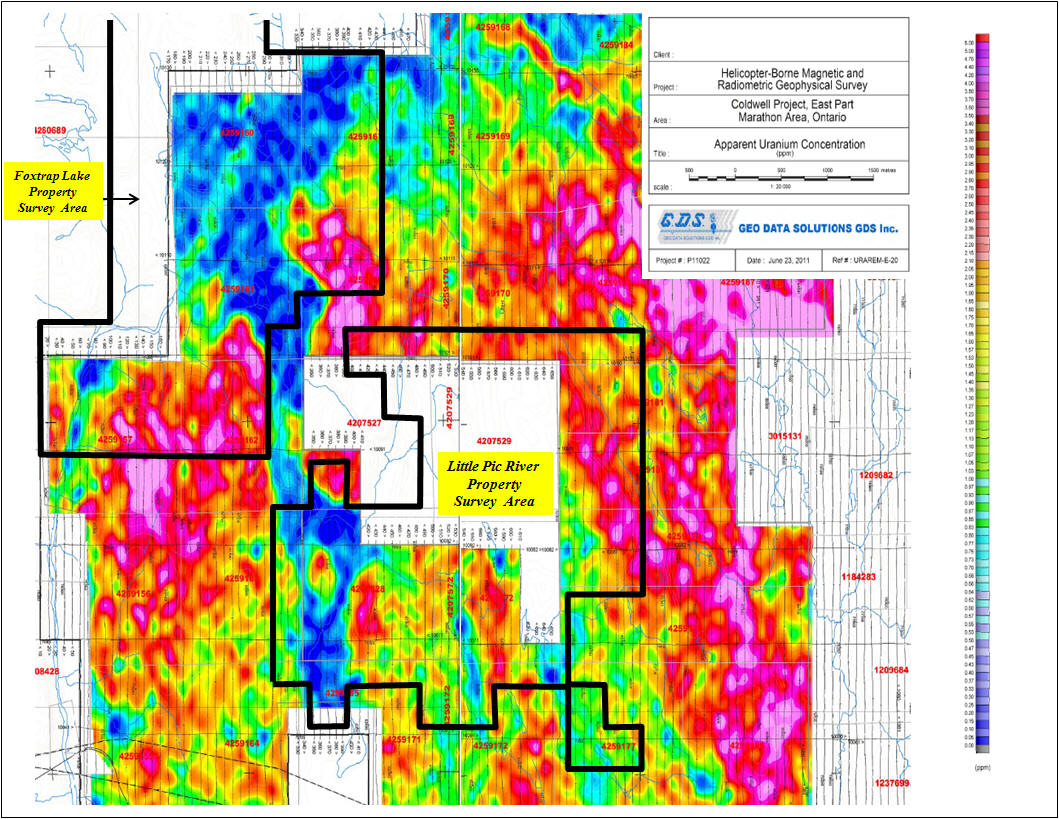
Little Pic River - Foxtrap Lake Property Helicopter – Borne Magnetic and Radiometric Geophysical Survey Data
|
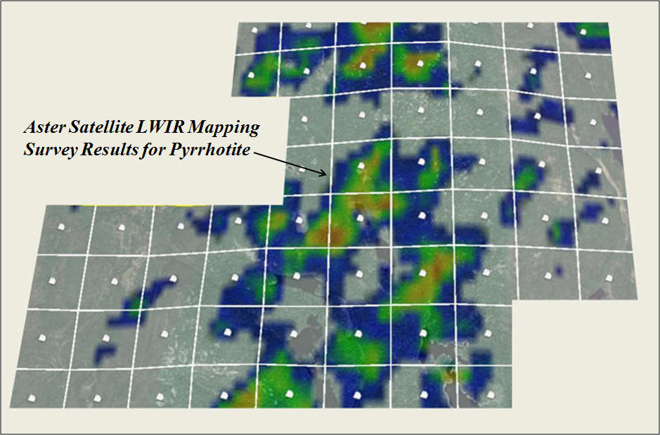
Aster Satellite LWIR Mapping Survey Results February 2022
Ontario Geological Survey digital records (geology, geophysics, historic and operating mines, mineral occurrences; drilling Etc.) in combination with the ASTER dataset makes an invaluable tool for exploration in the area and may assist in ground selection for future exploration on the property. The Aster Satellite LWIR Mapping survey results in indentifying a number of targets for exploration within the property. Site visits and ground inspection are required to further evaluate and interpret the data generated.
Aster Funds Ltd. Information at https://www.asterfunds.com/spectral-analysis
|
|
GEOLOGICAL SETTING AND MINERALIZATION
The Little Pic River Property is located at the western end of the Schreiber-Hemlo Greenstone Belt, which is part of the Wawa-Abitibi Terrane (WAT) of the Superior Province in Ontario. Rocks within this terrane across the province, share similar lithological, geochemical and age characteristics, and structural and metamorphic histories (Stott et al. 2010). The WAT is a typical Archean greenstone-granite terrane consisting of primitive ultramafic to felsic volcanic rocks and associated metasedimentary rocks, intruded, and enclosed by granitoid rocks. It is bounded in the north by the Quetico metasedimentary basin or subprovince (Magnus 2019, Stott 2011). The WAT contains a series of greenstone belts of similar age (ca. 2.95 to 2.68 Ga) hosting gold, nickel, and zinc deposits. In Northwestern Ontario, these deposits include the Hemlo Gold Mine at Marathon (located approximately 55 km east of the Martinet Jim Lake Property) and past producers; the Geco VMS (Cu-Zn) Mine at Manitouwadge, the Shebandowan Ni-Cu Mine and the Winston-Pick Lake VMS Zn-Cu Mine north of Schreiber.
|
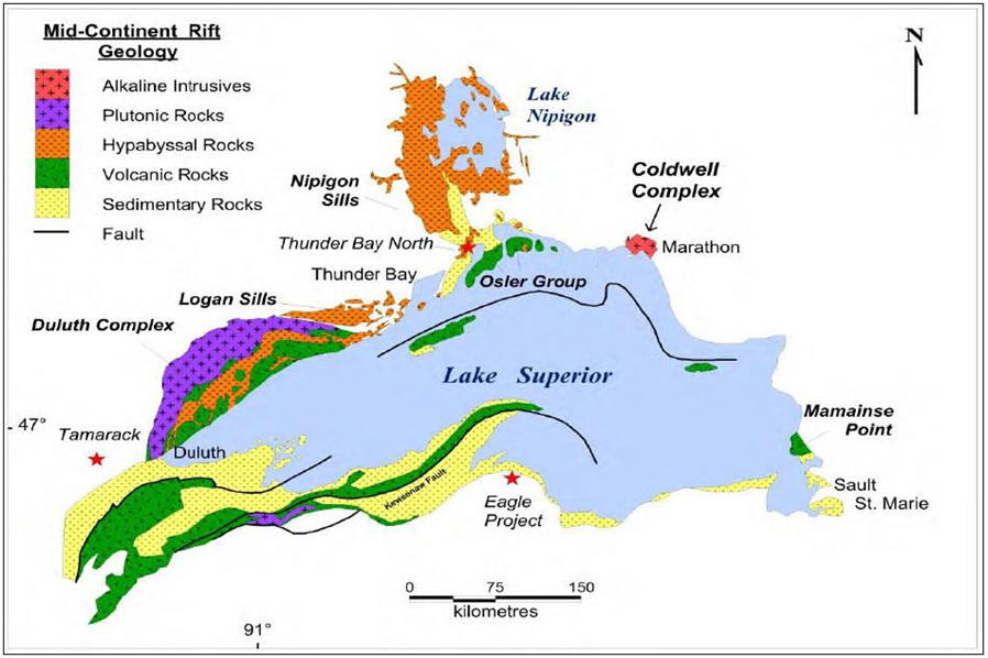
Figure 4. Proterozoic Geology, Lake Superior Region (Modified after Gignac et al. 2021, from
Generation Mining Limited Feasibility Study Technical Report, March 23, 2021
| The western portion of the Little Pic River Property straddles the boundary between rocks of the much older Archean Schreiber-Hemlo Greenstone belt and the younger Proterozoic Coldwell Complex Intrusion at between 1108 and 1094 Ma (Heaman and Machado, 1992 and Heaman et al., 2007) (Figure 4). The sub-circular Coldwell Complex (CC) has a diameter of 25 km and a surface area of 580 km2 and is the largest alkaline intrusive complex in North America (Walker et al. 1993). As part of the CC, the Eastern Gabbro occupies the northern and eastern margin of the complex and is host to Generation Mining Limited’s Marathon Pd-Cu Deposit (Figure 5). The company completed a Feasibility Study in March of 2021 and the deposit currently hosts a Proven and Probable Mineral Reserve Estimate of 2.34 Moz Pd @ 0.619 g/t, 532 Mlb Cu @ 0.205%, 255,000 oz Au, 756,000 oz Pt and 5.33 Moz Ag (Gignac et al. 2021). |
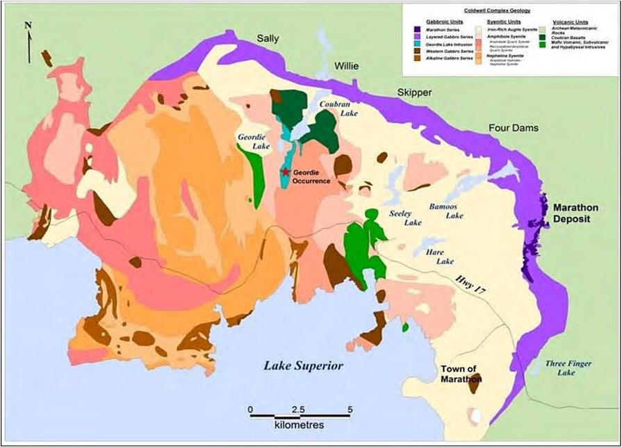
Figure 5. Geology of the Coldwell Complex (Modified after Walker et al. 1993, from Marathon
PGM Corp. 2010)
|
EXPLORATION HISTORY
The mineral potential of the Marathon area is considered high, based on the increased global demand for mineral resources together with extensive exploration activity in the Coldwell Complex and surrounding Schreiber-Hemlo Greenstone Belt. Most of the recent mineral exploration in the Coldwell Complex has focused on Cu-PGM+/-Au mineralization hosted in the peripheral gabbro ring of the Coldwell Complex. Gabbroic rocks occur continuously over a 20 km distance along the eastern and northern margins of the Coldwell Complex. Additionally, smaller portions of gabbro occur within the central Coldwell Complex and discontinuously along the southwestern margin (Good and Crocket 1994). Occurrences of rare metal (Nb, U, Zr, Th, and rare earth elements), building stone, industrial minerals and semi-precious gemstones occur within the syenitic rocks throughout the Coldwell Complex (Walker et al. 2021). Generation Mining is developing the 82.6%-owned Marathon Palladium-Copper project North of Marathon. A 2021 Feasibility Study shows a 30% Internal Rate of Return, a $1.07 billion NPV (6%) and a 2.3-year payback at a US$1725 palladium and US$3.20 copper price (Gignac et al. 2021). The Marathon deposit is the largest undeveloped palladium project in North America. A large percentage of the palladium mined today is used in automobile catalytic converters, which scrub toxic emissions from exhaust to control air pollution.
1993: Marathon PGM Corporation and Benton Resources Inc. controlled significant mineral exploration projects along the eastern and northeastern margin of the Coldwell Complex. Also during this period, other exploration companies were actively exploring the Archean metavolcanic rocks immediately surrounding the Coldwell Complex for gold and base metal deposits. They included: (i) Pelangio Mines Incorporated; (ii) Benton Resources Inc.; (iii) Phoenix Matachewan Mines Limited; and (iv) MetalCORP Limited. Additionally, local prospectors conducted work on key properties within the Coldwell Complex and in the surrounding greenstone belt.
2007: Marathon PGM controlled the most advanced Cu-PGM+Au project within the Coldwell Complex. Mineralization occurs in the Two Duck Lake Gabbro, located on the eastern margin of the Coldwell Complex. During this period, the company completed a diamond drilling program consisting of 180 holes totaling 40,000 m (Marathon PGM Corporation, news release, October 24, 2007). Results from a fence of drill holes (M-07-403, 405, 406, 410, & 417) collared outside the western margin of the known resource at the time, intersected wide intervals of mineralization up to 120 m, grading 0.97 g/t PGM+Au and 0.35% Cu (ibid). Resource estimates completed in early 2007, by P&E Mining Consultants Incorporated for Marathon PGM, reported a Measured Resource of 39.2 Mt containing 1.6 Moz of PGM+Au and 285 Mlb of Cu and Indicated Resource of 28.9 Mt containing 1.1 Moz of PGM+Au and 178 Mlb of Cu (NI 43-101 compliant). Benton Resources Bermuda property was located along the northwest strike extension of the Marathon PGM deposit. The company completed 66 diamond drill holes totaling close to 10,000 m, covering a strike length of 15 km. Highlights from drill holes BO-07-48 and BO-07-54, returned assays grading up 1.91 g/t PGM, 0.31% Cu over 33 m and 2.19 g/t PGM, 0.31% Cu over 23.5m respectively (Benton Resources Inc., news release, September 10, 2007). In the central portion of the Coldwell Complex, L.E.H. Ventures Incorporated reported a resource from four mineralized zones within the Geordie Lake Pd-Cu Property. In 2002 independent consultants for the company, Giroux and Stanley Consultants, estimated an Indicated Resource of 24.4 Mt averaging 0.326% Cu, 0.537 g Pd/t, 0.007% Co, 0.011% Ni, 0.030 g Pt/t, 2.52 g Ag/t and 0.04 g Au/t and an Inferred Resource of 5.4 Mt averaging 0.36% Cu, 0.626 g Pd/t, 0.007% Co, 0.012% Ni, 0.04 g Pt/t, 3.04 g Ag/t and 0.05 g Au/t (NI 43-101 compliant). E.C. Walker et al (1993) of the Ontario Geological Survey (OGS), in Open File Report 5868, Precambrian Geology of the Coldwell Alkalic Complex, reported several other Cu-PGE occurrences hosted by gabbro in the central and western portion of the Coldwell Complex. The Willie Lake occurrence located in the northern central portion of the Coldwell Complex returned grades up to 1.42% Cu over 6 m, reported from 1962-63 drilling by Head of the Lakes Iron Mine Ltd. Along the western margin of the Coldwell Complex, grab samples collected by Walker’s field crew returned copper grades up to 0.70% (1993, p.4). Additionally, Walker reported four types of rare metal (Nb, U, Zr, Th, and rare earth elements) occurrences found in pegmatite’s associated with amphibole syenite. Nepheline syenite, an industrial mineral product, was targeted for extraction during the 1950s to 1970s at three locations within the Coldwell Complex: Red Sucker Cove, Port Coldwell and Pic Island. Other notable rare metal and rare earth element occurrences are located within the Dead Horse Creek and McKellar Diatremes in the western metamorphic-contact-aureole of the Coldwell Complex (Sage, 1982, 1987, 1995). Smyk et al. (1993) of the OGS reported assays ranging up to 11.6% Zr, 0.6% Be, 2.5% Th, 250 ppm Sc, 1850 ppm Y, 300 ppm Nb, 903 to 1004 ppm and 4600 ppm U.
|